 |
concordia-memories.org
Recalling Concordia's Past
|
| View previous topic :: View next topic |
| Author |
Message |
roger.pape
Site Admin
Joined: 17 Mar 2009
Posts: 414
Location: Liverpool, NY
|
 Posted: Sun Jan 29, 2017 2:53 pm Post subject: Sanborn Insurance map overlays Posted: Sun Jan 29, 2017 2:53 pm Post subject: Sanborn Insurance map overlays |
 |
|
In an early posting (Sanborn Fire Insurance Maps of Concordia), I discussed the Sanborn maps from the late 1800s and early 1900s that show the various buildings in Concordia at that time. A followup to that posting illustrated how one can identify buildings and their location in old photographs using those maps.
It occurred to me that a simpler way to identify the location would be to overlay the maps on a Google Maps display. You can also see what is currently located there. That capability was added to this website. It can be accessed from the Maps page or with the following link: http://concordia-memories.org/Sanborn/sanborn.html
The alignment of the maps is not perfect. (The width of the streets on a Sanborn drawing is exaggerated.) But give it a try and let me know what you think. You may find some surprises.
|
|
| Back to top |
|
 |
roger.pape
Site Admin
Joined: 17 Mar 2009
Posts: 414
Location: Liverpool, NY
|
| Posted: Mon Feb 27, 2017 11:24 am Post subject: Sandborn Maps for Other Locations in Missouri |
|
|
| If you are interested in maps of other locations in Lafayette County or other parts of Missouri, check the University of Missouri Digital Collections.
|
|
| Back to top |
|
|
roger.pape
Site Admin
Joined: 17 Mar 2009
Posts: 414
Location: Liverpool, NY
|
| Posted: Tue Apr 11, 2017 9:11 am Post subject: What's there now? |
|
|
Have you seen an old building in the Sanborn maps and are wondering what is located there now? The Street View mode in Google maps is a convenient way to check this. The user interface for Street View is a bit "quirky", but after using it for a while, you should be able to master it.
Google sends its vehicles down the streets and roads of various localities photographing the view from street level. With this photography posted online, one can move the display down a street or road and see what the view would be from a vehicle traveling down it. Concordia was visited by Google in Aug 2008, May 2009, Jun 2013, and Nov 1016. By default, the latest photography is displayed when one first enters Street View. But there is a little known feature which allows one to switch to any of the other dates.
First of all, one enters Street View from a Google Maps display. This is done by dragging the little yellow person in the lower left of the window onto a street or road that has a blue line superimposed on it when you drag the figure. (These are the streets that Google has photographed.) Perform this operation from the map display with the Sanborn map overlays and the display will change to a street view at the point where you drop the figure. To look around from that point, click on the display and drag it left or right to rotate the view around. To move back or forth, click on the street/road in the direction you want to move. [Note. If you want to get back to the map view, click on the left arrow in the black box at the upper left corner.]
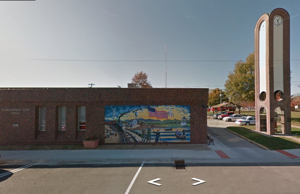
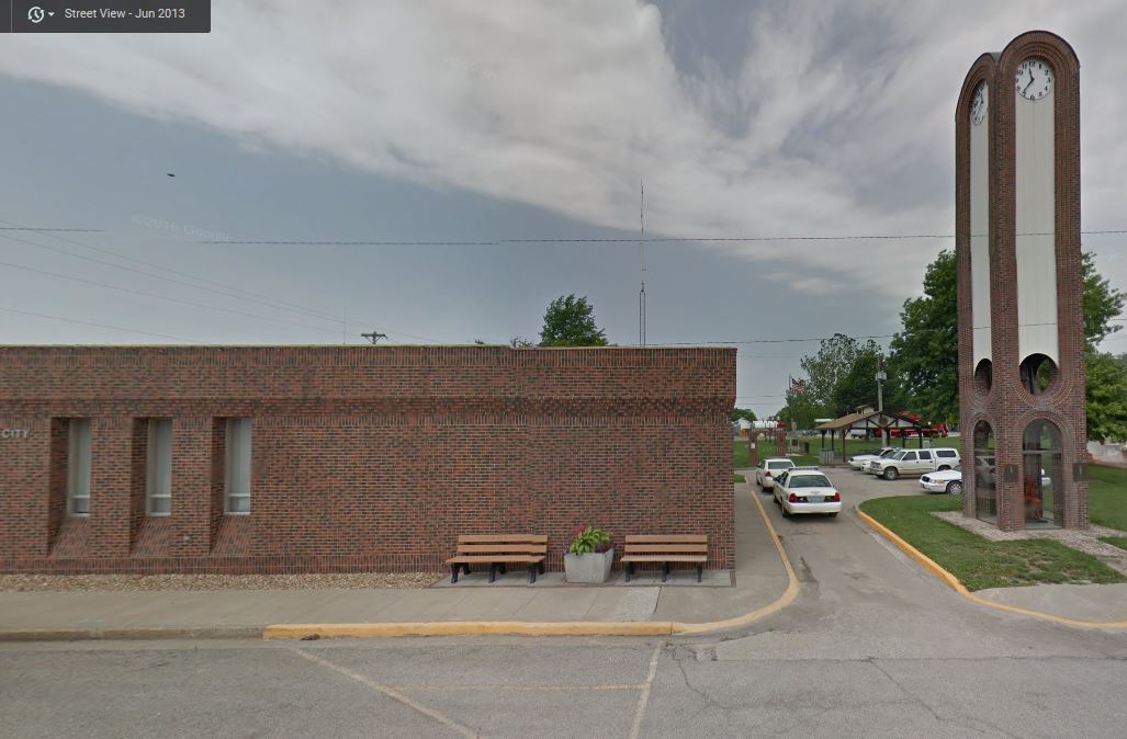
For example, if you want to see the view of what currently stands at Secco Brockman's Concordia Produce Company, drop the figure in the middle of Schiller (Main) Street along side that building (the current location of City Hall). You may then have to drag the display right or left to see the building. Notice the mural on the front side in the Nov 2016 photography. To change to a different date, click on 'View on Google Maps' in that same black box. This will bring up a separate window with the same view. Notice that the bottom of the black box shows a new line with the date of the photography currently being viewed. Click on the clock icon on the left and an additional box pops up giving you a choice of dates to display. Click on the second dot from the right on the time line and then on the thumbnail display in that box. The photography will change to Jun 2013. Now the mural is missing. So it was added sometime between Jun 2013 and Nov 2016.
Moving up or down Main St., you can use this same technique to view the storefront of various businesses and see whether they have changed. Of course, this is only useful for the period since 2008.
Changing the view by clicking, dragging, or expanding will often cause the display to change in unexpected ways. Don't be frustrated. Simply back up and try again.
| Description: |
| Nov 2016 Street View of Concordia City Hall |
|
| Filesize: |
92.61 KB |
| Viewed: |
30722 Time(s) |
|
| Description: |
| Jun 2013 Street View of Concordia City Hall |
|
| Filesize: |
100.09 KB |
| Viewed: |
30722 Time(s) |
|
|
|
| Back to top |
|
|
|
|
You cannot post new topics in this forum
You cannot reply to topics in this forum
You cannot edit your posts in this forum
You cannot delete your posts in this forum
You cannot vote in polls in this forum
You cannot attach files in this forum
You can download files in this forum
|
Powered by phpBB © 2001, 2005 phpBB Group
|

